Kumrat is a stunning valley and a famous tourist destination located in the Upper Dir District of Khyber Pakhtunkhwa the Province of Pakistan. Kumrat Valley is situated at a distance of 370 km (230 miles) from the capital city of Islamabad at an approximate travel time of 8 hours and 30 minutes. The spectacular natural attractions of Kumrat Valley can be reached via the alternative southern route through Timergara (Dir) or through the northern route through Kalam (Swat).
Kumrat Valley Location and Geographically
The exact geolocation of Kumrat Valley on Google Maps is 35°32’13.5″N 72°13’09.5″E. The Main Road, Kumrat, Upper Dir, Khyber Pakhtunkhwa 47281, Pakistan is considered the base station for tourist attractions and other places to visit in the surrounding areas of the Valley.
Kumrat is geographically surrounded by its administrative centre upper Dir district in the West, Swat Valley (Kalam Valley, Gabral, & Utrar) in the east, Drosh in the East, and other parts of Chitral in the northeast.
Islamabad to Kumrat Valley (Distance / Route Map / Location)
The total distance between Islamabad and Kumrat Valley is approximately 370 km (230 miles) which is nearly 9 hours of drive. The route between Islamabad and Kumrat is via M1 (Islamabad-Peshawar Motorway) and then at Colonel Sher Khan Interchange via M16 (Swat Motorway) towards Chakdara. Onwards; the N45 route, Dir Road, and finally Kumrat Road maps and connects Islamabad to Kumrat Valley.
How to Visit Kumrat Valley by Road
The easiest way to get to Kumrat by road is to take the N45 route (also known as Chakdara Road) from Chakdara town in the Lower Dir District of Khyber-Pakhtunkhwa in Pakistan. The starting point of the N45 route at the south end of Lower Dir District at Chakdara is a known junction and is also a motorway interchange to the Swat Motorway.
Chakdara being the starting point of your journey towards Kumrat Valley in the north is well linked to Islamabad in the south, and Swat in the northeast through Swat Motorway (M16).
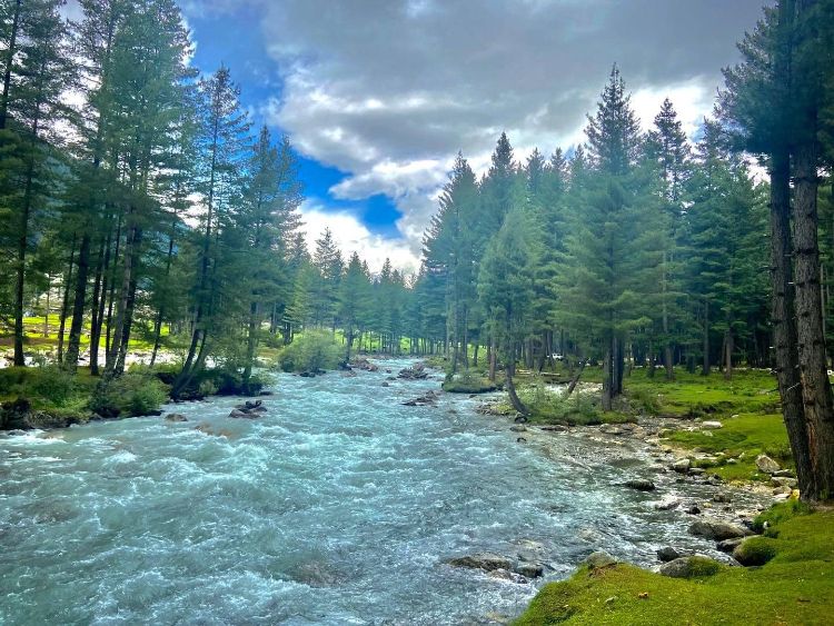
From Chakdara to Kumrat Valley the total distance is approximately 177km (110 miles) which is roughly around 6 hours and 30 minutes of drive time. Most of the journey is alongside the bank of the beautiful Panjkora River which makes the journey more scenic and exciting. Panjkora River itself is one of the famous attractions when visiting Kumrat. The Panjkora River is at an elevation of 3,600 m (11,800 ft) and runs a length of 220 km (140 mi) through the beautiful lush green mountains of the Dir District and in Kumrat Valley.
The 1st part of the journey from Chakdara to Baabe-e-Kumrat at Chutiatan is through N45 which is around 100km (62 miles) and approximately 2 hours and 50 minutes. This part of the Journey to Kumrat is relatively comfortable and is full of discoveries as you pass through the main towns and places such as Timergara, Barron, Toormang Wari, Shib Abad, Darora, and finally reach to Baabe-e-Kumrat at Chutiatan.
The 2nd part of the journey from Baabe-e-Kumrat to the Kumrat Valley is the off-N45 route on Dir Road and is more adventurous and closer to nature. The total distance from Baabe-e-Kumrat to the main Kumrat town which is called Kumrat road is approximately 78km (48.5 miles) which is roughly another 3 hours and 40 minutes further drive. This route to Kumrat is actually a diversion to the right side at Chutiatan Chutiatan when you are leading N45 towards Lowari Tunnel and Chitral. The main point of attractions or at least places where you can take journey short breaks are Sheringal, Biar, and Tall.
Alternative Route to Kumrat Valley
An alternative route to Kumrat Valley is through Swat Valley. The total distance between Mingora Swat and Kumrat Valley is approximately 156km (97 miles) which is roughly 6 hours of drive. This route is from Airport Road via Matta or through N95 through Khwazakhela. This route passes through other tourist attractions and famous places to visit in swat such as Madyan, Bahrain, Kalam, Utrar (Utroor), Gabral, etc. The distance between Kalam and Kumrat Valley is approximately 63km (39 miles) which is roughly just over 3 hours of drive.
While you are in Swat, especially in Kalam Valley or surrounding places, it might be very tempting to take this alternative short route to Kumrat. Bear in mind that this route “Utrar to Dir Road” is not a smooth drive and therefore can be challenging but can be a great attraction for adventurists.
Kumrat Tourist Attractions & Places to Visit in Kumrat Valley
There are many attractions and places to visit in the Kumrat Valley, covering a wide area that is just waiting for you to explore! Perhaps Kumrat valley is the most famous gem of a place to visit in the Dir District.
There are breathtaking lakes, soaring mountains, picturesque valleys, green lush forests, and other natural attractions in Kumrat. These wonders of nature make Kumrat the most beautiful place to visit on everyone’s list when they are in Khyber Pakhtunkhwa, Pakistan.
1. Kumrat Town Centre
2. Jaaz Banda (Jahaz Banda) Kumrat
3. Kumrat’s Katora Lake
4. Kumrat Panjkora River
5. Kumrat Majestic Mountains
6. Kumrat National Park
7. Kumrat Wild Life
8. Kumrat Wild Trout Habitat
9. Kumrat Valley Jungle
10. Kumrat Waterfall
11. Kumrat Camp Site (Camping Pods)
The Best Time to Visit Kumrat Valley
The best time to visit Kumrat valley for the summer holidays is during May, June, July, August, and September when the temperature is pleasant between 5.6 °C (42.1°F) and 16.2 °C (61.2 °F). Kumrat Valley in winter (December, January, and February) experiences cold weather when the temperature drops to -16.1 °C (3.1°F) or even lower suitable for snowfall experience and winter sports activities. Other months in Kumrat such as March, April, October, and November are mostly pleasant but slightly on the colder side.
Kumrat Valley Weather & Temperature
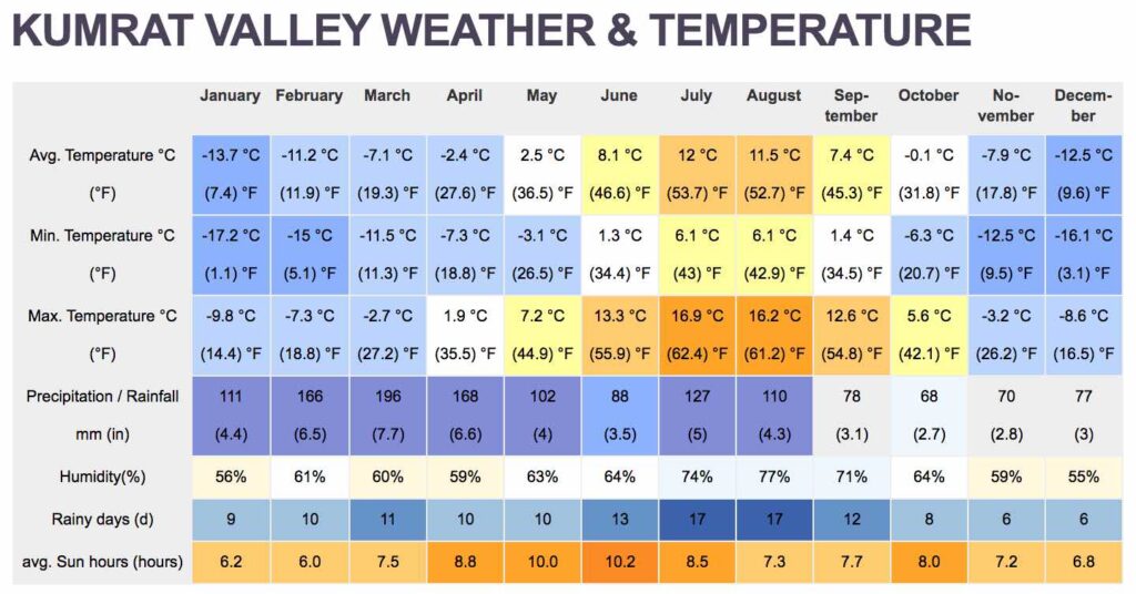
Summary of weather and overall temperature in Kumrat Valley.